| Scale |
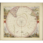
Scale approximately 1:30 000 000 ; stereographic projection (W 180°--E 180°/S 20°--S 90°) |
| Physical description |
1 map : hand coloured ; 43 cm diameter, on sheet 52 x 59 cm. |
| Notes |
Circular title from the centre of the map. |
|
Relief shown pictorially. |
|
A hemispherical map within a square frame, centred on the South Pole to the Tropic of Capricorn. showing southern parts of South America and South Africa, the west and south coasts of Australia, and parts of Tasmania and New Zealand. A Polar continent is dilineated partly by island chains and partly by line. At the centre of map are the words Terra Australis Incognita.The sheet corners are completely filled in with large vignettes of native scenes including animals, birds, boats and a representation of a penguin. |
|
First published by Henricus Hondius, and subsequently by Jansson, De Wit, Gerard Valk and Pieter Schenk in four varying states over a period of sixty years. Part of Mercator's "Atlantis Majoris", published in various editions, including Dutch, Latin, French, and German translations. The first state of the map shows Australia prior to the discoveries of Tasman in 1642 and 1643-44. The second state lists "Ioannes Iansonnius" as the publisher in the title cartouche. The third state also lists "Ioannes Iansonnius" as publisher but omits the blank cartouche, and includes several discoveries not present on the first or second states of the map. The fourth and final state of Polus Antarcticus was first published in 1652. It omits the title cartouche and includes further new discoveries including parts of New Zealand and Tasmania. This 1700 version of the fourth state is without text verso but has the imprint “Apud G. Valk et P. Schenk Amstel.” |
|
The inscription "Nova Hollandia detect Anno 1644" refers to Tasman's second voyage. |
| Acquisition source |
Purchase; 20190123 WLB |
| Provenance |
Acquired from Leen Helmink WLB |
| Subjects |
Antarctica -- Maps -- Early works to 1800.
|
|
Australia -- Maps -- Early works to 1800.
|
|
South America -- Maps -- Early works to 1800.
|
| Genre/Form |
Early maps. lcgft
|
| Related names |
Valck, G. (Gerard), 1651-1726, publisher.
|
|
Schenk, Peter, 1661-1711, publisher.
|
|