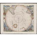
| Scale |
Scale approximately 1:30 000 000 ; stereographic projection (W 180°--E 180°/S 20°--S 90°) |
| Physical description |
1 map : hand coloured ; 44 cm in diameter, on sheet 50 x 59 cm. |
| Notes |
Includes title cartouche. |
|
Relief shown pictorially. |
|
A hemispherical map within a square frame, centred on the South Pole to the Tropic of Capricorn. showing southern parts of South America and South Africa and the west and south coasts of Australia. A Polar continent is dilineated partly by island chains and partly by line. At the centre of the map are the words Terra Australis Incognita.The sheet corners are completely filled in with large vignettes of native scenes including animals, birds, boats and a representation of a penguin. |
|
First published by Henricus Hondius, and subsequently by Jansson, De Wit, Gerard Valk and Pieter Schenk in four varying states over a period of sixty years. Part of Mercator's "Atlantis Majoris", published in various editions, including Dutch, Latin, French, and German translations. The first state of the map shows Australia prior to the discoveries of Tasman in 1642 and 1643-44. The second state lists "Ioannes Iansonnius" as the publisher in the title cartouche. This is an example of the third state which also lists "Ioannes Iansonnius" as publisher but omits the blank cartouche, and includes several discoveries not present on the first or second states of the map. The fourth state omits the title cartouche and includes further new discoveries including parts of New Zealand and Tasmania. |
|
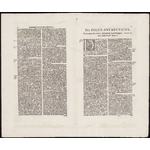
On verso: "Den Polus Antarcticus, en de onder den felven gheleghene Landtschappen, nevens de adaer aeftootende Zee-en." In Dutch, black type, 2 column text with ornate initial and printed marginal headings. |
| Indexed by |
Globe, no. 54, 2003 0311-3930 |
| References |
Tooley, 729 |
| Acquisition source |
Purchase; 20170728 WLB |
| Provenance |
Acquired from Leen Helmink. WLB |
| Subjects |
Antarctica -- Maps -- Early works to 1800.
|
|
Australia -- Maps -- Early works to 1800.
|
|
South America -- Maps -- Early works to 1800.
|
| Genre/Form |
Early maps. lcgft
|
| Related names |
Jansson, Jan, 1588-1664, publisher.
|
|