Aboriginal and Torres Strait Islander peoples are advised that the State Library of Western Australia catalogue includes images, sounds, and names of deceased persons.
All users should be aware that certain words, terms, or descriptions may be culturally sensitive and considered inappropriate today, but reflect the period in which they were written.
Your session will expire automatically in 0 seconds.
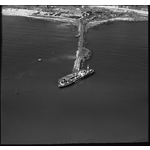
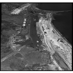
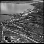
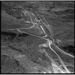
Aerial photographs of damage caused to the construction of Iron mining facilities at King Bay (Dampier) and the Dampier-Tom Price Railway by Cyclone Shirley, 3 April 1966 [picture]
For personal use only. To publish or display, contact the State Library of Western Australia.
Notes
Title from label on photograph envelope.
This image has been preserved and made available by the Historical Records Rescue Consortium Project supported by Lotterywest.
All images may only be reproduced with the acknowledgement: Courtesy of Aerial Surveys Australia.
Summary
Cyclone Shirley crossed the coast at King Bay on 2 April 1966 with winds up to 204km/hr causing damage to the iron mines, port construction and railways being built for the iron mining industry in the region. Construction under way for the iron ore mining facilities at King Bay to receive ore from Mt Tom Price for Hamersley Iron which will be railed to King Bay. Originally King Bay was to be the township also, but later the town was built at what became Dampier. (At the beginning, King Bay, Dampier by Marie Dickson)