Aboriginal and Torres Strait Islander peoples are advised that the State Library of Western Australia catalogue contains includes images, sounds, and names of deceased persons.
All users should be aware that certain words, terms, or descriptions may be culturally sensitive and considered inappropriate today, but reflect the period in which they were written.
Your session will expire automatically in 0 seconds.
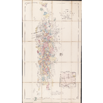
Map showing the gold mining leases in the Direct Hannan's Belt Kalgoorlie, East Coolgardie Goldfield, Western Australia [cartographic material] / C.W. Cropper.
1 map : mounted on linen, col. ; 100 x 59 cm. folded to 22 x 11 cm.
Notes
Shows mining leases in the Hannan's Belt from North of Kalgoorlie townsite to Gnumballa (Hannan's) Lake with number, name and size of lease, company or syndicate names and water rights.
Also shows Kalgoorlie townsite, batteries, and pipeline from Gnumballa Lake to the Great Boulder and Lake View batteries.
Includes locality map.
Compiled from surveyor's notes under the direction of Messrs. Gledden and Manning, Authorised Mining Surveyors, with the sanction of the Government of W.A. This edition lithographed by H.E.C. Robinson, Sydney.