Aboriginal and Torres Strait Islander peoples are advised that the State Library of Western Australia catalogue contains includes images, sounds, and names of deceased persons.
All users should be aware that certain words, terms, or descriptions may be culturally sensitive and considered inappropriate today, but reflect the period in which they were written.
Your session will expire automatically in 0 seconds.
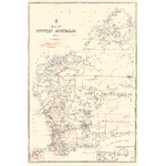
Map of Western Australia showing electoral district boundaries and provinces overprinted in red on topographical base. Relief shown by hachures.
Insets: Enlargement of Perth and vicinity; small scale world map showing ocean routes, and small map of Australia showing railroads and telegraph lines.
"Hon. Geo. Throssell MLA Minister for Lands" ; "Harry F. Johnston Surveyor General" -- under Dept. Insignia.
Compiled by the Dept. of Lands and Surveys and published as a plate in the Statistical Register of Western Australia for 1900 in Part V, facing p. 2.