| Call Number |
940.542694 GOS |
| Variant title |
Planned Japanese invasion of Australia and New Zealand |
| Physical description |
12, 258 pages (some folded) : all illustrations, maps ; 25 x 40 cm. |
| Notes |
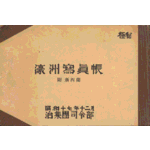
The book contains index. On the cover, it says 'Top secret' in Japanese; in the preface, it says 'This is a revised edition of same title, earlier produced in two volumes'. The captions in English contain numerous mistakes. |
|
Published in December 1942, according to the information on the cover. |
|
Published and read from back-to-front. |
|
Variant title devised by the cataloguer. |
| Language |
Captions in English and Japanese. |
| Summary |
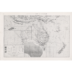
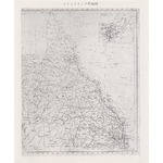
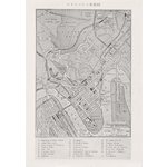
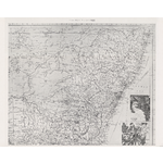
A rare album relating to the Japanese Imperial Army's plan to invade Australia and New Zeland during World War Two. Compiled and issued by the headquarters of the Japanese Rikugun in Jakarta. This book consists of reproductions of photographs of major geographical and topical features, major cities and industrial infrastructure, such as dams, mines, smelters and factories in Australia & New Zealand, as well as of vertical aerial photographs: five aerial photographs of Darwin and four of Bathurst Island, both in the the Northern Territory, taken by Japanese, and 52 other aerial photographs of Ballarat area and Mornington manoeuvre area, Victoria, dated 1937 and 1938 at the end of the book include the acronym CAS, indicating they were taken by Commonwealth Aviation Services. Reduced images of maps of Australian states and territories and of New Zealand, are included as foldouts; among them is a 1941 map of Canberra. The maps are annotated to indicate the locations of the various photographed features. The photographs seem to be copied from commercially available sources, including government and private industrial publicity brochures. The book was intended for the use of Imperial Japanese Army and Air Service personnel as an aid to identifying targets of strategic importance in Australia and New Zealand. These targets could potentially be destroyed either through bombing raids or in an invasion by Japanese ground forces. One of the most highly targeted areas was Mornington and its environs; there are also numerous aerial views of Darwin and Broome, which were both bombed by the Japanese. |
| Subjects |
World War, 1939-1945 -- Japan.
|
|
World War, 1939-1945 -- Campaigns -- Australia.
|
|
World War, 1939-1945 -- Campaigns -- New Zealand.
|
|
Australia -- Pictorial works.
|
|
New Zealand -- Pictorial works.
|
|
Australia -- Maps.
|
|
New Zealand -- Maps.
|
| Related names |
880-03 Japan. Rikugun. Gun, Dai 16. Shireibu.
|
|
880-03 Japan. 陸軍. 軍, 第 16. 司令部.
|
|