| Physical description |
39 maps ; 89 x 62 cm. or smaller. |
| Series |
[Historic map series, Western Australia] |
|
[Historic map series, Western Australia]
|
| Notes |
Series C covers Central Western Australia. |
|
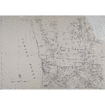
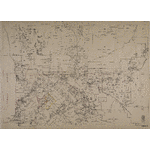
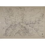
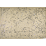
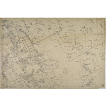
Western Australian historical maps series of 1880-1890s of 1in. = 300 chains and 1in. = 80 ch. predominantly, with some outlying pastoral areas being 1in. =800 ch. reduced from the 1in. = 300 ch. series. Maps of pastoral areas based on early surveyors works of trigonometrical and traverse surveys constructed without any geographical control, the sheets extended as required using rectangular coordinates to plot the detail. Relief shown by hachures. |
|
Title supplied by cataloguer. |
|
State Library of Western Australia's holdings of these maps are incomplete. Index map published separately, in the 1970s and filed in the Battye Library Reading Room. Index map does not reflect holdings. |
|
For details of holdings see CN 9 in the Battye Library Reading Room. |
| Summary |
Maps show State Land Divisions, pastoral leases with number, lessee, area, boundary length; location numbers; tracks, roads and their gazettal date, stopping places along main roads; telegraph lines, railways and townsites; rivers, watercourses, aboriginal wells, mountains and other topography. Battye collection encapsulated in plastic. Formerly 298C. |
| Subjects |
Western Australia, Central -- Historical geography -- Maps.
|
|